AI-Driven Mining Intelligence. From Data Capture to Decision Ready Dashboards
AI-Driven Mining Intelligence. From Data Capture to Decision Ready Dashboards
Aereo Cloud transforms drone data into short-term planning intelligence, enabling faster reconciliation, safer operations, and near-real-time decision visibility across mining operations.
Trusted by Industry Leaders


Explore Client Success Stories
Explore Client Success Stories
Delivering operational intelligence at enterprise scale.
Delivering operational intelligence at enterprise scale.
0+
0+
mine surveys
0M+
0M+
images processed
0k+
0k+
sq km mapped
Across India & Global Mining Enterprises
Across India & Global Mining Enterprises
Role Based
Aereo Cloud: One Platform, Role Specififc Outcomes
An integrated workflow transforming site data into decision-ready intelligence within hours

Executive Leadership
Enterprise-wide visibility with custom dashboards, data-backed decisions for early risk detection, and assured compliance, risk control, and ROI.
Mine Planning & Geology
Operations & Site Management
Innovation & Technology

Mining Reimagined Through AI
Mining Reimagined Through AI
Periodic Surveys → Continuous Visibility
Periodic Surveys → Continuous Visibility
Fragmented Data → Unified Mine View
Fragmented Data → Unified Mine View
Manual Checks → Automated Intelligence
Manual Checks → Automated Intelligence
Conventional Workflow
Delayed survey cycles due to manual site surveys
Slow plan-vs-actual and reconciliation due to manual terrain interpretation
Fragmented mine data across tools, teams, and reports
Reactive safety reviews after haul road, slope, or drainage issues emerge
Aereo's AI Powered Workflow
Automated drone data capture and processing enables near real-time mine visibility.
AI-powered terrain analysis accelerates plan-vs-actual and reconciliation.
Centralized cloud platform creates one unified mine view.
AI-based monitoring of terrain feature enables earlier risk visibility and control.
End-to-end Workflow
AI Powered End-to-End Intelligence across your Mining Lifecycle
AI Powered End-to-End Intelligence across your Mining Lifecycle
From exploration to closure, Aereo Cloud converts site reality into measurable operational, financial, and safety outcomes, powered by automated drone capture, AI analytics, and cloud integration.
Exploration
Land Acquisition
Mine Planning
Production Monitoring
Safety & Compliance
Closure & ESG
01
02
03
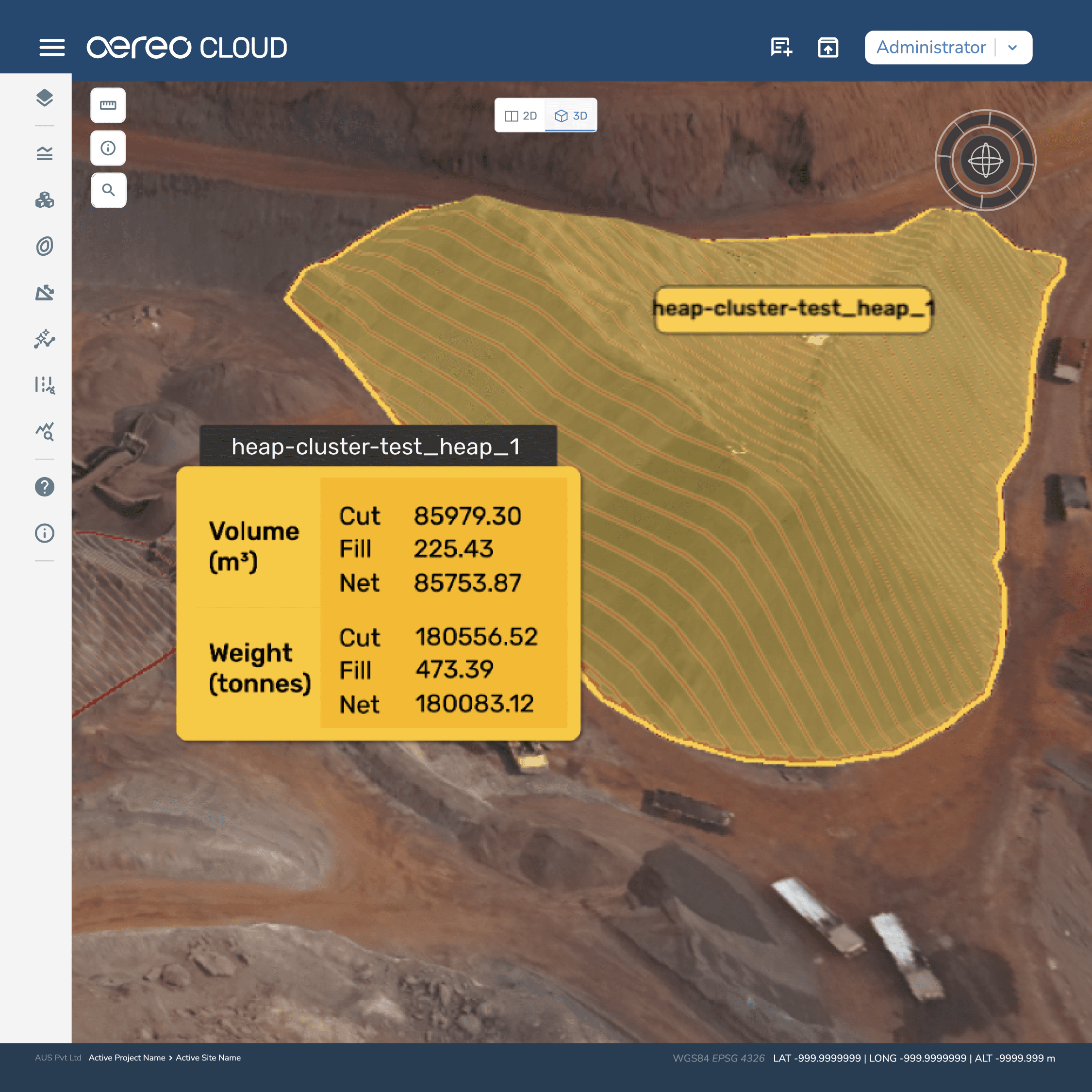
Track production progress with clearer surface and volume visibility.
Aereo Cloud computes cut-fill and stockpile volumes from high-resolution surface models generated from drone imagery.
Upto 98% reconciliation accuracy
demonstrated in production workflows using DEM-based, auditable reconciliation.
01
02
03
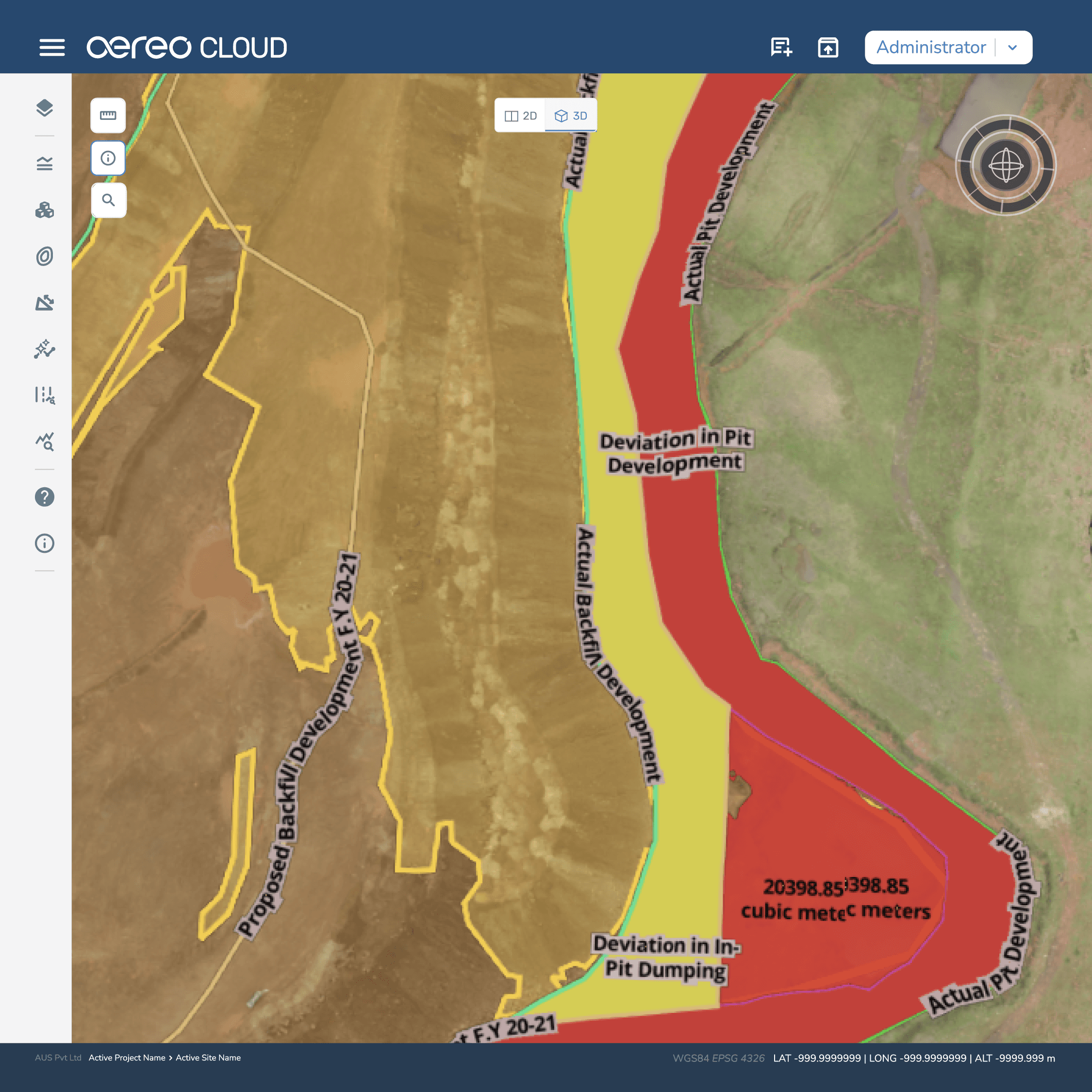
Bring plan vs actual reconciliation into one visual workflow.
Aereo Cloud allows uploaded mine design files to be visually overlaid on the latest terrain model for surface-level variance assessment.
Weeks to
0hours
survey turnaround achieved in deployment, giving planners near real-time visibility.
01
02
03
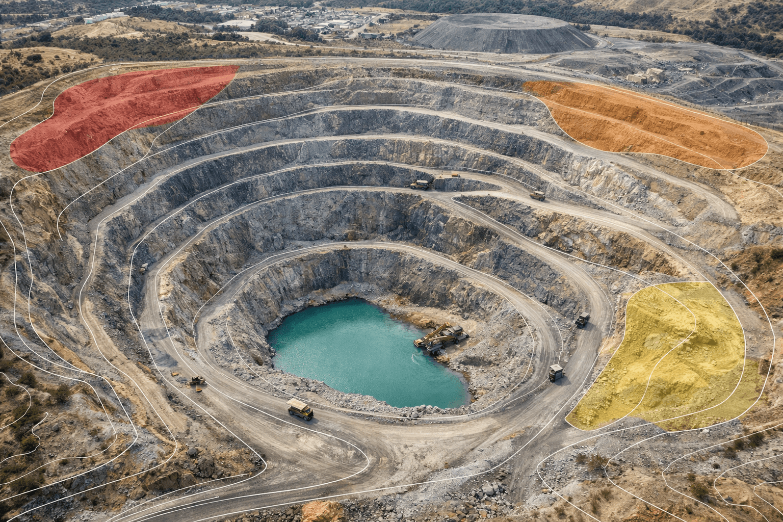
See surface change between survey cycles without piecing data together manually.
Aereo Cloud compares consecutive terrain datasets to highlight excavation progress, stockpile movement, and surface-level variance over time.
1 day analytics delivery & <10 day reporting proved the shift from delayed reporting to continuous operational visibility.
Exploration
Land Acquisition
Mine Planning
Production Monitoring
Safety & Compliance
Closure & ESG
01
02
03
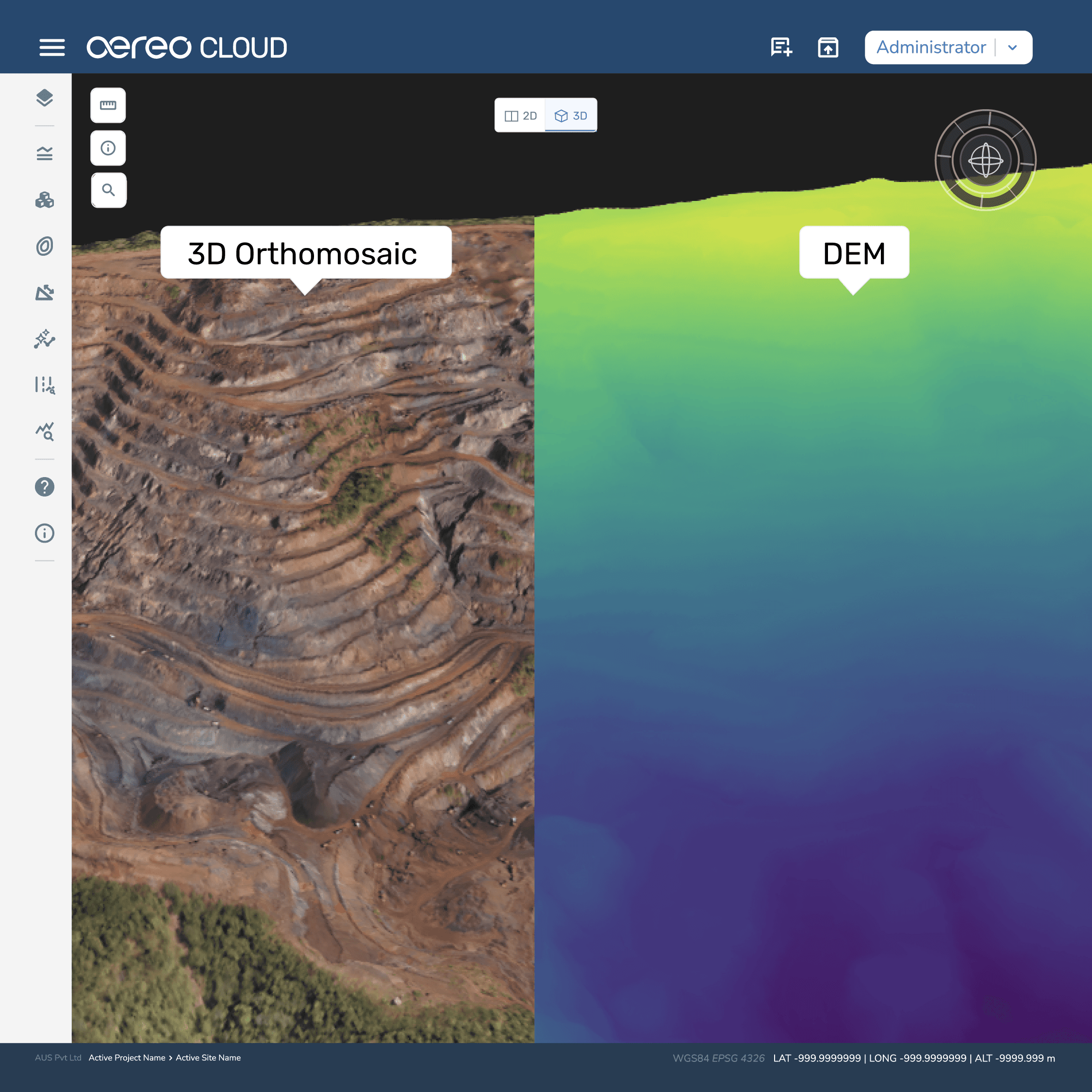
Make early-stage terrain validation faster and more reliable.
Aereo Cloud generates high-resolution orthomosaics, Digital Elevation Models, and contour outputs from drone-captured imagery, giving exploration teams a current terrain base for surface understanding and early feasibility review.
0k+ sqkm
Terrain validation across mapped mining regions for early-stage feasibility
01
02
03
See topographic conditions clearly before planning begins.
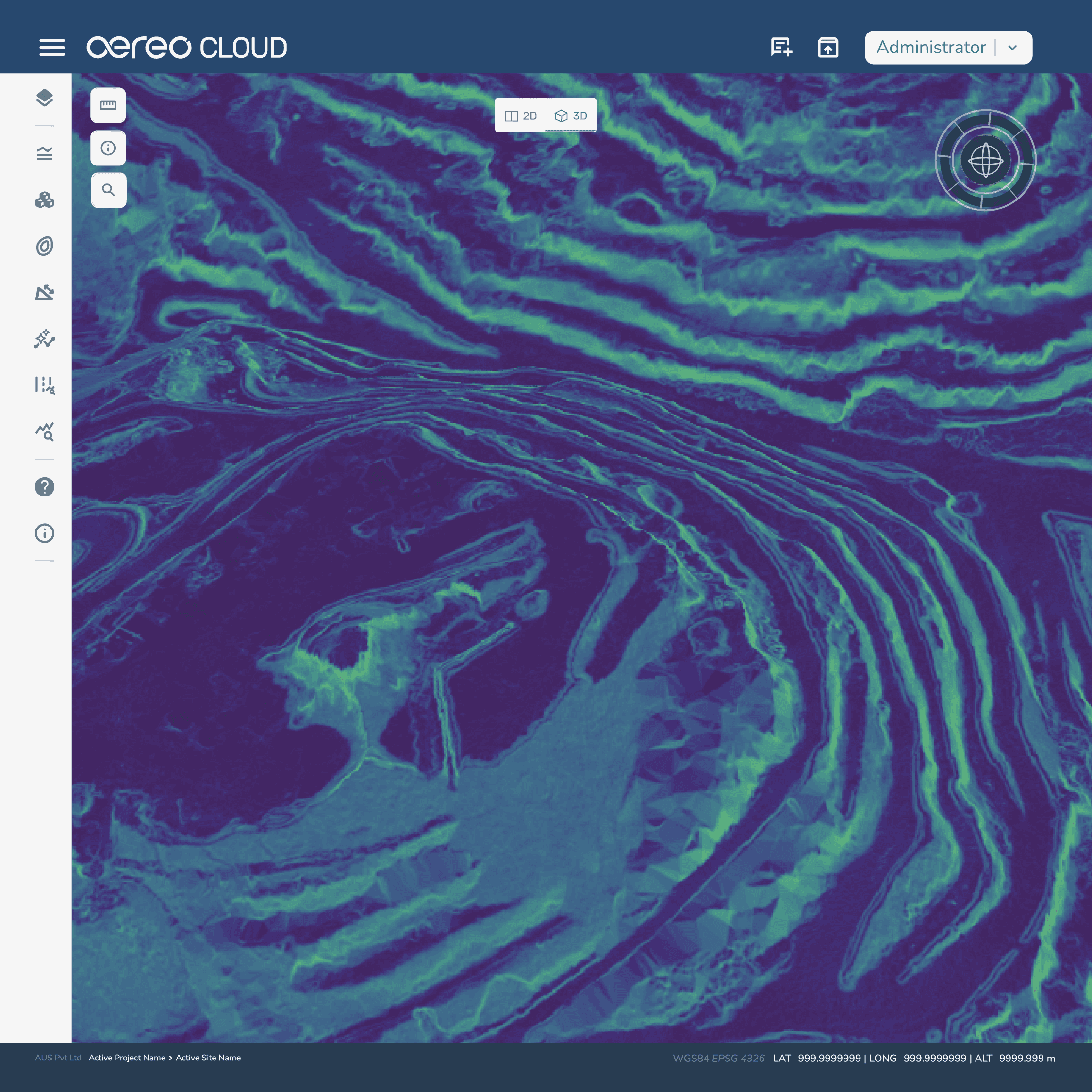
Processed surface models in Aereo Cloud automatically derive slope gradients, elevation intervals, and contour detail, helping teams review terrain conditions with greater clarity before downstream planning decisions begin.
Upto sub
0-3 cm resolution
demonstrated in deployments, improving surface-level terrain interpretation quality.
01
02
03
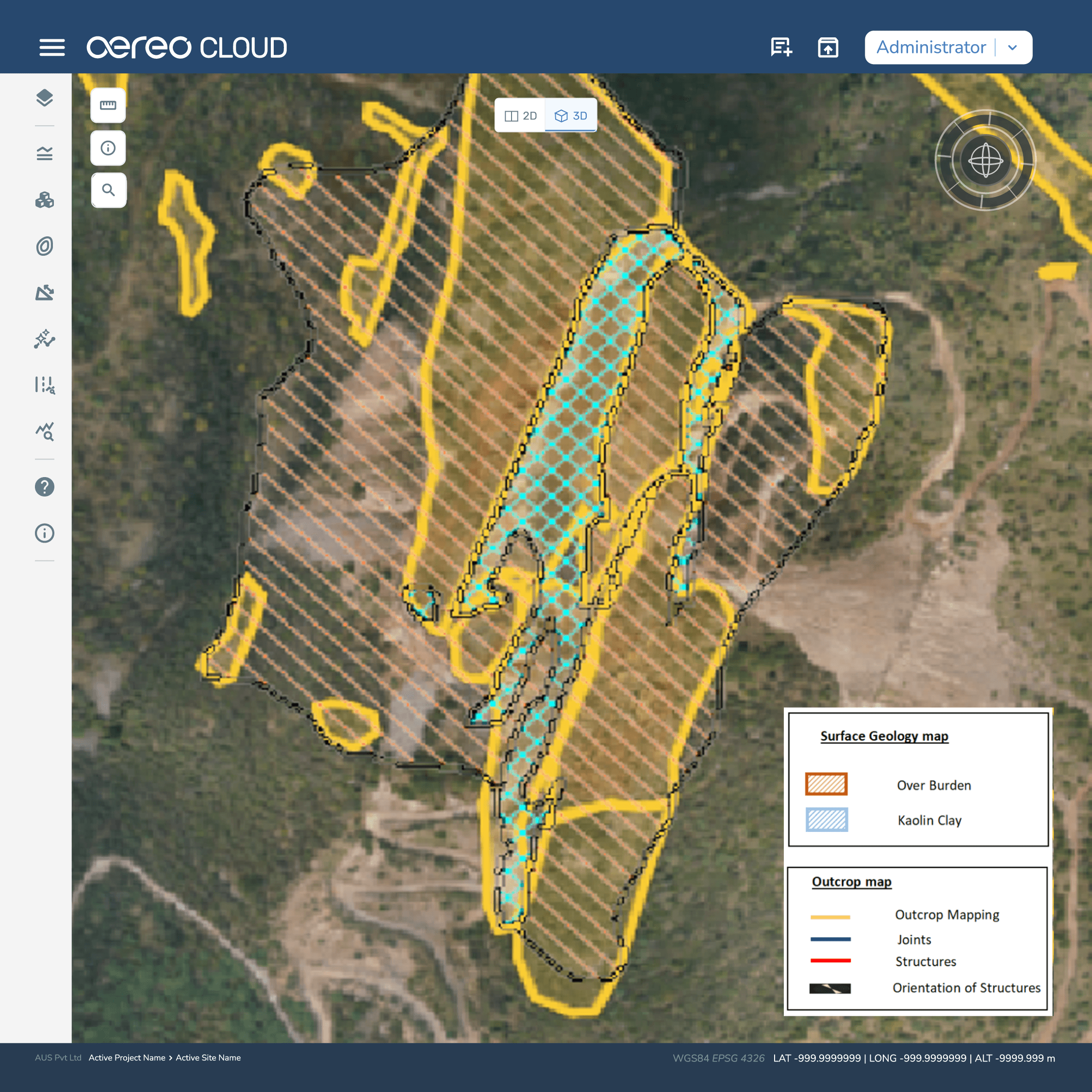
Bring surface intelligence into geological review.
Aereo Cloud helps teams visually identify outcrops and terrain features within high-resolution orthomosaic imagery, making surface-level exploration analysis easier to review and act on.
0M+ images
processed across Aereo Cloud workflows, reinforcing enterprise-scale image intelligence.

Aereo and Datamine Announce Global GTM Partnership
for delivering AI-enabled Mining Solutions.
Aereo and Datamine Announce Global
GTM Partnership for delivering
AI-enabled Mining Solutions.
Integration
Seamless Integration with Existing Mine Systems
Aereo Cloud integrates into your existing planning and operational systems, enabling closed-loop intelligence without replacing your core software stack.
Mine planning softwares


Cloud platforms


GIS & Spatial Softwares


No software disruption. Unified mine visibility.
Integration
Seamless Integration with Existing Mine Systems
Aereo Cloud integrates into your existing planning and operational systems, enabling closed-loop intelligence without replacing your core software stack.
Mine planning softwares
Cloud platforms
GIS & Spatial Softwares
No software disruption. Unified mine visibility.
Platform Tools
Aereo Cloud Tools for Modern Mining
Aereo Cloud Tools for Modern Mining
Upload RGB drone imagery
Import GCP files (TXT, CSV)
Upload geotag files
Support multiple coordinate systems
Import SHP, TIFF, KML,
MBTiles, CSV
Upload RGB drone imagery
Import GCP files (TXT, CSV)
Upload geotag files
Support multiple coordinate systems
Import SHP, TIFF, KML, MBTiles, CSV
Testimonials
Don’t just take our word for it
Don’t just take our word for it
"We've been actively using Aereo's drone solutions for volumetric assessment since the better half of this decade regularly, even on a weekly basis at our Mines and Captive Power Plants. Their drone mapping, volumetric analytics, and other solutions have significantly helped us streamline our processes at our plants and mines with better accuracy, improved operational efficiency and decision-making in our processes too."
Shouvik Majumder, VP Mining, Hindalco
"Aereo is one of the leading drone manufacturing and services company that has helped propel the SVAMITVA scheme as a reliable and competent partner with its drone manufacturing expertise and drone services portfolio offerings to capture images for more than 40,000 villages across the country. Drone survey offers cost-effective solutions to lot of challenges associated with cadastral mapping and record preparation or modernization of conventional processes."
Pankaj Mishra, Deputy Surveyor General, Survey of India
"Aereo (formerly AUS) is a go-to technology partner when it comes to conducting drone surveys and analytics in record time. They have lent their years of expertise to projects such as irrigation planning, urban and rural development, and archaeological surveys."
Rahul Johrapurkar, Jt. Managing Director, Ceinsys
"Our Tata Steel mines are spread across a vast area in States of Odisha & Jharkhand. Digital mine monitoring for high level mine visibility into operations is extremely important for compliance, safety and also higher productivity from mines. The drone based digital mine mapping, volume survey and mine analytics requires scalability with accuracy. Aereo's end to end solutions, especially their cloud platform has helped us achieve these key metrics and implement them at a large scale."
Piyush Srivastava, Chief NRD, Tata Steel

"We've been actively using Aereo's drone solutions for volumetric assessment since the better half of this decade regularly, even on a weekly basis at our Mines and Captive Power Plants. Their drone mapping, volumetric analytics, and other solutions have significantly helped us streamline our processes at our plants and mines with better accuracy, improved operational efficiency and decision-making in our processes too."
Shouvik Majumder, VP Mining, Hindalco

"Aereo is one of the leading drone manufacturing and services company that has helped propel the SVAMITVA scheme as a reliable and competent partner with its drone manufacturing expertise and drone services portfolio offerings to capture images for more than 40,000 villages across the country. Drone survey offers cost-effective solutions to lot of challenges associated with cadastral mapping and record preparation or modernization of conventional processes."
Pankaj Mishra, Deputy Surveyor General, Survey of India

"Aereo (formerly AUS) is a go-to technology partner when it comes to conducting drone surveys and analytics in record time. They have lent their years of expertise to projects such as irrigation planning, urban and rural development, and archaeological surveys."
Rahul Johrapurkar, Jt. Managing Director, Ceinsys

"Our Tata Steel mines are spread across a vast area in States of Odisha & Jharkhand. Digital mine monitoring for high level mine visibility into operations is extremely important for compliance, safety and also higher productivity from mines. The drone based digital mine mapping, volume survey and mine analytics requires scalability with accuracy. Aereo's end to end solutions, especially their cloud platform has helped us achieve these key metrics and implement them at a large scale."
Piyush Srivastava, Chief NRD, Tata Steel
"We've been actively using Aereo's drone solutions for volumetric assessment since the better half of this decade regularly, even on a weekly basis at our Mines and Captive Power Plants. Their drone mapping, volumetric analytics, and other solutions have significantly helped us streamline our processes at our plants and mines with better accuracy, improved operational efficiency and decision-making in our processes too."
Shouvik Majumder, VP Mining, Hindalco
"Aereo is one of the leading drone manufacturing and services company that has helped propel the SVAMITVA scheme as a reliable and competent partner with its drone manufacturing expertise and drone services portfolio offerings to capture images for more than 40,000 villages across the country. Drone survey offers cost-effective solutions to lot of challenges associated with cadastral mapping and record preparation or modernization of conventional processes."
Pankaj Mishra, Deputy Surveyor General, Survey of India
"Aereo (formerly AUS) is a go-to technology partner when it comes to conducting drone surveys and analytics in record time. They have lent their years of expertise to projects such as irrigation planning, urban and rural development, and archaeological surveys."
Rahul Johrapurkar, Jt. Managing Director, Ceinsys
"Our Tata Steel mines are spread across a vast area in States of Odisha & Jharkhand. Digital mine monitoring for high level mine visibility into operations is extremely important for compliance, safety and also higher productivity from mines. The drone based digital mine mapping, volume survey and mine analytics requires scalability with accuracy. Aereo's end to end solutions, especially their cloud platform has helped us achieve these key metrics and implement them at a large scale."
Piyush Srivastava, Chief NRD, Tata Steel
Frequently Asked Questions
Frequently Asked Questions
Get answers to common questions here
Get answers to common questions here
How scalable is Aereo Cloud?
Aereo Cloud is proven at scale with 3,752+ mine surveys, 1,200+ stockyard surveys, and 15M+ acres mapped, delivering 99% accurate volumetric estimates across operations.
What accuracy can I expect?
Do I need specialized hardware?
Can it support multiple sites and teams?
How scalable is Aereo Cloud?
Aereo Cloud is proven at scale with 3,752+ mine surveys, 1,200+ stockyard surveys, and 15M+ acres mapped, delivering 99% accurate volumetric estimates across operations.
What accuracy can I expect?
Do I need specialized hardware?
Can it support multiple sites and teams?
Learn How Aereo helped Coal India Save 250K USD on Fuel Cost
Submit the form to access the Coal India Limited case study.
Learn How Aereo helped Coal India Save 250K USD on Fuel Cost
Submit the form to access the Coal India Limited case study.
